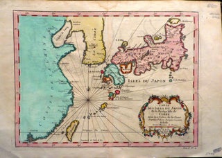
Essay D'une Carte Reduite, Contenant Les Parties Connuees du Globe Terrestre. Dedie a M le Comte de Maurepas, Commandeur des Ordres du Roy Ministre et Secretaire d'Etat.
1748. 740mm x 520mm. No Binding. Hand-coloured world map by Bellin depicting the known parts of the terrestrial globe. Slight folding creases. 740mm x 520mm. The date on the map is 1748, but this edition is up-dated to include the full outlines of Australia and New Zealand, with 'Antipodes de..... More