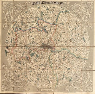
24 Miles round London
London: G F Crunchly, 1839. No Binding. Canvas-backed, folding, travel map with circular image, 31 x 30 cm, coloured. Extremely attractive item. More
London: G F Crunchly, 1839. No Binding. Canvas-backed, folding, travel map with circular image, 31 x 30 cm, coloured. Extremely attractive item. More
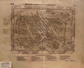
No Binding. Original German wood engraving of a map showing a birds-eye view of the city of Bordeaux c. 1620, showing the city walls, buildings and streets, the castle, cathedral, Roman ruins, the port with ships in the harbour, and surrounding countryside. Includes an index of the principal features of..... More
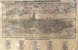
No Binding. City map with birds eye view for1588 with key to major features such as churches, main thoroughfares, walls, etc. c. 1630. Slight creasing down the middle, distorting a little the wording in the key at the bottom 30 x 50 cm. More

1710. No Binding. 35 engravings of the plans of fortified cities and towns in rural France, from the period of the War of the Spanish Succession, 1701-1714.They include notable cities such as Cahors, Chalons sur Saone, Orleans, Chartres, etc. The maps show fortifications, earthworks, rivers and waterways, and both town..... More
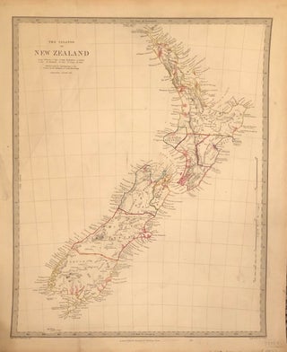
London: Edward Stanford. No Binding. Hand-coloured map of New Zealand showing North and South Islands, outlining provincial districts. Includes cities, towns, rivers etc. 36 x 43.5 cm. Published for the Society for the Diffusion of Useful Knowledge. Engraved by J & C Walker. c 1840. More
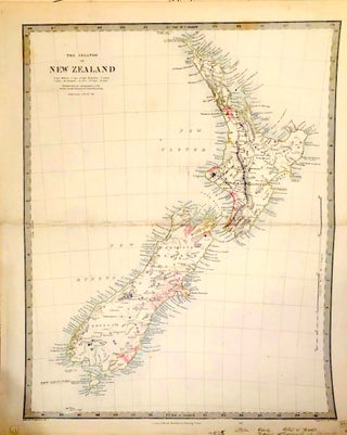
London: Edward Stanford. No Binding. Hand-coloured map of New Zealand showing North and South Islands, showing provincial districts. Includes cities, towns, rivers etc. 36 x 43 cm.One centre crease. Published for the Society for the Diffusion of Useful Knowledge. Engraved by J & C Walker. c 1835. More
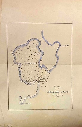
No Binding. Hand-coloured map showing St Georges Head, Montague Rd, Bowen Island and Beecroft hHead. Tracing from Admiralty chart. 33 x 22 cm. Repairable tear in top portion of map otherwise good. Shows small sections around the coast and larger interior ones, Nugget's Point lighthouse, Cannibal Bay, Catlins lake, etc...... More
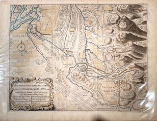
London. No Binding. Detailed engraved hand-coloured map of the "The Lines of Stolhoffen in Alsacia betwixt Strasburg & Fort Lewis. Attacked by the French, April the 23, 1703." Showing battle lines and positions, contours and geographical features such as buildings, fortifications, fields and rivers. Inset "Explanation" being an index index..... More
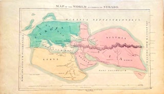
Edinburgh: Call & Inglis, 1850. No Binding. Hand-coloured map centred on the Mediterranean based on the map made by the Classical Greek geographer Strabo from his work "Geographica". Map published by the prominent Edinburgh map-making firm of Call & Inglis, established in 1810. Excellent copy of an interesting classical map..... More
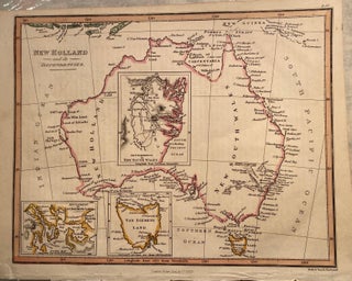
London: Fisher & Son, 1829. No Binding. Hand-coloured map of Australia with insets of Van Diemens Land, and settlements in New South Wales and Van Diemens land. Published by Fisher and engraved by the printers and engravers Neele & Son. 26 x 20.5 cm. More
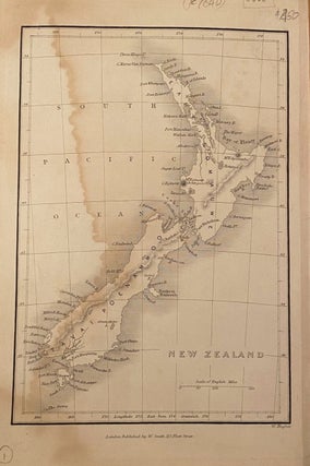
London: W Smith. No Binding. c. 1840. Shows New Zealand with North Island as Eahe Inomauwe and South Island as Tavai Poenammoo. Heavy art paper. A pale water stain through image. 25.5 x 17 cm. More
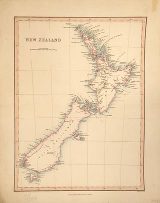
London: Charles Smith & Son. No Binding. Hand-coloured rare original map of New Zealand c 1830. 33 x 42 cm. More
London: George Philip. No Binding. Coloured lithograph showing both islands of NZ with full geographic details. c 1850s 58 x 54 cm. One short marginal tear and lacks lower left had marginal corner. Attractive large, early item. More
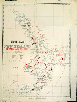
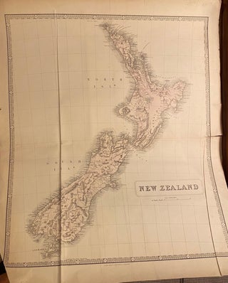
Wellington: NZ Government Printer. No Binding. Double-sided map of New Zealand showing North and South Islands on separate sides, outlining provincial districts. Includes cities, towns, railways, coach routes. 34 x 43 cm. Some small tears on edge of folds. More
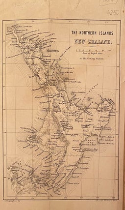
Edinburgh: Schenk & McFarlane. Original Cloth. Map of the North Island showing missionary stations, geographical features and towns and settlements. c 1850. Short repair to lower part of page. 14.5 x 23 cm. More
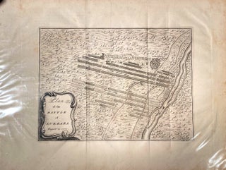
No Binding. Detailed engraved B&W map of the battlefield, showing battle lines and positions, contours and geographical features such as buildings, fortifications, fields and rivers. 40 x51 cm. Free floating under mylar. c.1740s. The Battle of Luzzara took place early in the war, in Lombardy between a French force and..... More
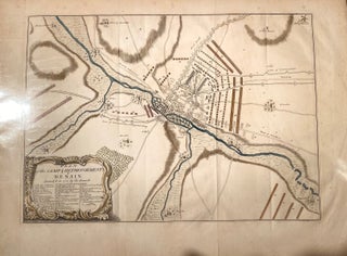
No Binding. Detailed engraved hand-coloured map of the battle site of the Battle of Denain, showing battle lines and positions, contours and geographical features such as buildings, fortifications, fields and rivers. Inset index of major features and events in the campaign. Battle site from the War of the Spanish Succession..... More
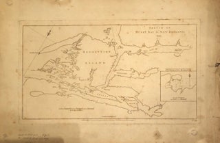
London: W Strahan, 1777. No Binding. Map of the Dusky Bay area, including inset of Pikersgill Harbour, from Cook's second voyage. 34 x 49 cm. Some small tears on margins not affecting the image. More
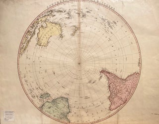
London: W Eaden, 1802. No Binding. Circular map projected from the South Pole. Based on Cook's famous map, showing New Zealand, Australia (New Holland) Pacific Islands, South America and South Africa. 59 x 75 cm. Hand-coloured with very pale stain on fold, otherwise in excellent condition. More

Folio. No Binding. Single sheet cosmological map of the earth with its co-ordinates, including the tropics, equator, and polar circles, particularly showing Antarctica. Includes text. Rare page from an early Spanish book on cosmology, 1690-1720. More
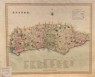
London: Henry Teesdale & CO, 1831. No Binding. Hand-coloured map of Sussex showing market towns, turnpikes, churches and chapels, rivers and canals, seats of the nobility, with a key to Rapes and Hundreds. One of the noted series from Teesdale's "New British Atlas" of 1831. 46 x 37 cm, free..... More
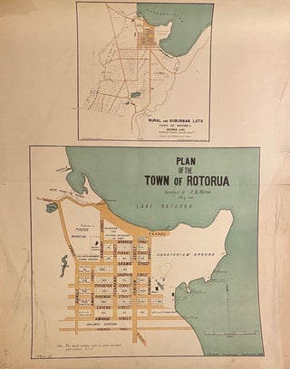
1881. No Binding. Coloured lithograph showing detail of the town sections, sanatorium grounds, railway station, "native" village of Ohinemutu. Includes smaller plan of rural and suburban lots in town of Rotorua, and rural sections which will be further divided, surveyed by A B Morrow and R C Reay. S Percy..... More

John Bartholomew, 1896. No Binding. Coloured lithograph. Detailed folding map showing glaciers, mountains and ranges, rivers, including the Cook and Karangarua Rivers out to their estuaries on the West Coast. 41 x 47 cm. More

1748. 740mm x 520mm. No Binding. Hand-coloured world map by Bellin depicting the known parts of the terrestrial globe. Slight folding creases. 740mm x 520mm. The date on the map is 1748, but this edition is up-dated to include the full outlines of Australia and New Zealand, with 'Antipodes de..... More
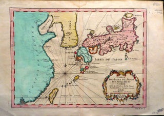
1758. BELLIN, N. 370x250mm. No Binding. Coloured Map: 29 x21.5 cm, with margins 37 x25 cm. Excellent condition, centre crease. Small stain in top margin. (c.1758). A rare, early hand-coloured map, showing the coast of China, Korea, & Japanese Islands. More